Figure 5: the road condition of the R3W China’s Two-Lane Two-Way highway
near Yunjinghong (Banomyong et al., 2006)
Then, the last section of the Bangkok-R3W-Kunming route is the route 540 km R3 highway, which links Yunjinghong and Kunming. From Yunjinghong to Xuxi the highway is four-lane two-way and from Xuxi to Kunming is six-lane two-way. Figure 6 illustrates the road condition of Yunjinghong to Xuxi. Within the year 2007, China aims to finish the improvement of this highway by making it better and shorter.
Although the construction of this route has been significantly completed a few years ago, most merchants and logistics services providers are reluctant to use this route. The major barriers are located in Myanmar, which are 1) Myanmar political issues. 2) Policies of transit fee, and 3) Quality of the highway. The minor barriers are international logistics collaborations, which have been on the process of improvement (e.g. Cross-Border Transport Agreement).
The Bangkok-Mekong-Kunming Route :
The Bangkok-Mekong-Kunming route also uses the 830 km. Bangkok to Chiang Rai as the first section. Then, the second section is a local highway from Chiang Rai to Chiang San port, which is the Thai major port in the Mekong river. The length is about 60 km. Thai government has a plan to improve this section of highway into a 40 km route and to build the new port in the near-by location. The third section is Mekong river. All the goods have to be relocated from trucks to ships. The length of this section is about 287 km from Chiang San to Kuwnlei or about 360 km from Chiang San to Yunjinghong. The Yunjinghong port, other than Kuwnlei, is planned for passenger accommodation , but not for commodity transportation. Since the Kuwnlei port is about 75-80 km far from Yunjinghong, the
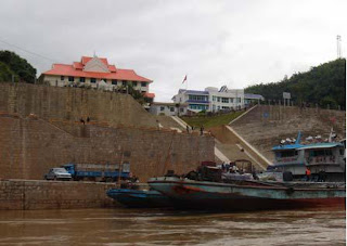
Kuwnlei port is positioned as a strategic port for the area. After all of the goods pass through the customs process, they are reloaded into trucks or near-by warehouses. The method of Logistics Channel loading and unloading between trucks and ships of the Mekong is still of primitive and man-power necessity . The crane and container system is still under the process of development. Then, the last section of this route is the R3 highway, as the same as the Bangkok-R3W-Kunming route. Figure 7 shows Typical China’s Port and Cargo Ship in the Mekong River
Figure 7: Typical China’s Port and Cargo Ship in
the Mekong River (Kuwnlai Port )
Nowadays, this route plays a main part serving the Thai and Yunnan logistics demands, particularly in the bulk commodities. However, this is still not effective, particularly during the first six months (November to May), during which the water levels of the river are low and the transportation capacity of the ships decrease significantly. For the worst case, during the dry season, the river water volume may not be enough for the transportation. However, China succeeded in improving the transportation efficiency of the upper Mekong river from Yunjinghong to Chiang Khong (Upper Mekong Navigation Improvement project). Risks of transportation in this river are relatively high, no insurance company officially guarantees the logistics services along this river, therefore the transportations normally do carry on during the daytime. Typically, the travel time between Chiang San and Yunjinhong is about 1 day upstream and 3 days downstream. Most transportation fleets are owned by Chinese, Loa, and Myanmar, respectively. Only skillful captains can effectively manage the ships. Due to the installation of several dams along the northern part of river, China can now control the transportation flows along this river. Practically, China has the advantages beyond other GMS countries in term of transportations. Furthermore, the issues of environmental impacts for these changes on the Mekong river are still questionable in terms of sustainability and fairness (Berman, 1998). The most barriers of transportation forn this route come from the natural and human factors. They can be summarized as
1) Volume of water during the dry season,
2) Risks due to the obstructions,
3) Environmental Impacts,
4) Political issues. Other barriers, such as infrastructure capability and logistics technologies can be feasibly improved step-by-step.

